Martin and Gilly Simons: Downside, Shoreham Test PitDay 1
27 April 2020
Since moving to our house 5 years ago, every time we planted a shrub it was very hard to get any depth easily, there seemed to be a hard layer of coal ash and clinker quite near the surface. Our house is built on what was a very large World War One army camp in Shoreham, existing from 1914 to 1919. It covered an area of farmland from west of Buckingham Park then east along the north side of Upper Shoreham Road as far as Southlands Hospital and stretched northwards on the Downs to beyond what is now the A27.
Up to 20,000 recruits were housed here at any one time!
https://shoreham-army-camp.worthingmuseum.co.uk/topics/welcome-to-the-camp-1/
So, we decided to dig a metre square test pit in the lawn (more weeds than lawn!), towards the end of our garden, away from our shrub planting efforts. With a little research we discovered we are close to a cookhouse and a drying room in Area 15.
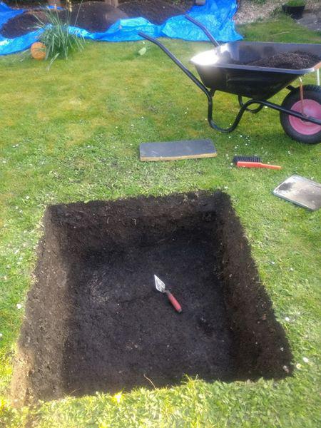
Off came the turf ready to start tomorrow, husband and wife team (wife didn’t want her photo taken)!
27 April 2020
Since moving to our house 5 years ago, every time we planted a shrub it was very hard to get any depth easily, there seemed to be a hard layer of coal ash and clinker quite near the surface. Our house is built on what was a very large World War One army camp in Shoreham, existing from 1914 to 1919. It covered an area of farmland from west of Buckingham Park then east along the north side of Upper Shoreham Road as far as Southlands Hospital and stretched northwards on the Downs to beyond what is now the A27.
Up to 20,000 recruits were housed here at any one time!
https://shoreham-army-camp.worthingmuseum.co.uk/topics/welcome-to-the-camp-1/
So, we decided to dig a metre square test pit in the lawn (more weeds than lawn!), towards the end of our garden, away from our shrub planting efforts. With a little research we discovered we are close to a cookhouse and a drying room in Area 15.
Off came the turf ready to start tomorrow, husband and wife team (wife didn’t want her photo taken)!
Downside, Shoreham Test Pit Day 2
It’s the second day, we got down through 8 inches of topsoil, lots of rubbish finds, bathroom tile, flowerpot, glass, asbestos cement sheet, bits of brick, lots of cinders, several pieces of sandstone of varying thickness, plastic, bits of flint (some interesting, details to follow when we have got through the topsoil) and some very anaemic skinny worms!
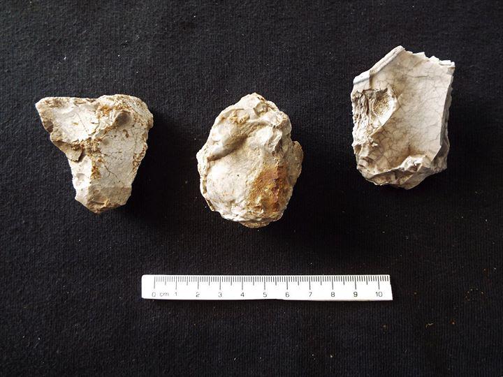
One photo for today, three pieces of burnt flint, I like to think probably prehistoric, can’t imagine a soldier would put flint in a hut stove!
It’s the second day, we got down through 8 inches of topsoil, lots of rubbish finds, bathroom tile, flowerpot, glass, asbestos cement sheet, bits of brick, lots of cinders, several pieces of sandstone of varying thickness, plastic, bits of flint (some interesting, details to follow when we have got through the topsoil) and some very anaemic skinny worms!
One photo for today, three pieces of burnt flint, I like to think probably prehistoric, can’t imagine a soldier would put flint in a hut stove!
Downside, Shoreham Test Pit Day 3
Still working down through topsoil, we went down another 6 inches with similar finds as before until we reached a layer of soft ash where the worms were very fat! We called it a day, could do no more, back ache! Mind you the digging was very easy compared with Sompting!
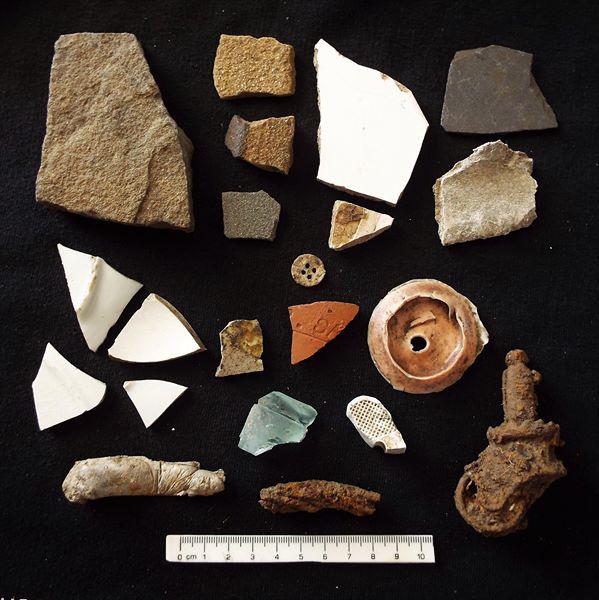
Today’s photo of miscellaneous finds left to right, a bit mixed up, top to bottom as follows: 4 pieces of sandstone, 2 of bathroom tile, slate, asbestos cement, 4 white china, 1 glazed pottery, fragment of glass jar neck, bit of flowerpot, thin alloy button, miscellaneous plastic, part of a doll, molten aluminium, piece of steel cable and a castor! This is just a selection of the best finds!!!! And a bonus find, a possible axe. Flint finds tomorrow.
Still working down through topsoil, we went down another 6 inches with similar finds as before until we reached a layer of soft ash where the worms were very fat! We called it a day, could do no more, back ache! Mind you the digging was very easy compared with Sompting!
Today’s photo of miscellaneous finds left to right, a bit mixed up, top to bottom as follows: 4 pieces of sandstone, 2 of bathroom tile, slate, asbestos cement, 4 white china, 1 glazed pottery, fragment of glass jar neck, bit of flowerpot, thin alloy button, miscellaneous plastic, part of a doll, molten aluminium, piece of steel cable and a castor! This is just a selection of the best finds!!!! And a bonus find, a possible axe. Flint finds tomorrow.
Downside, Shoreham Test Pit Day 4
My wife, Gilly, starts trowelling one side, after going through an inch of softish ash/clinker she says “Oh, feels like concrete”. I was a bit gutted she found it and not me! So, we scrape away and yes it does feel solid, impossible to trowel so had a good dig in and managed to break through, it was a two inch thick layer of compacted ash and clinker, really solid. Definitely not a floor as it wasn’t level and followed the downward contour of the slope, not a road surface as not thick enough to support a horse and cart. As it was 10 metres south of our shrub planting efforts it was clear that this compacted surface extended some distance, my guess is it was an assembly area or a very wide pathway between huts. We excavated this surface which was sitting directly on subsoil. There was one find directly underneath, a small piece of white china, probably from a plate or saucer, although I can’t imagine soldiers with saucers! We can assume that all the topsoil we have excavated is imported/created post 1919!
So, the mystery of the hard shrub planting was solved.
The excavation continues!
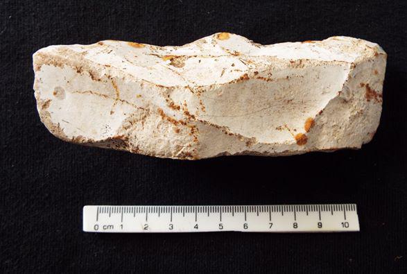
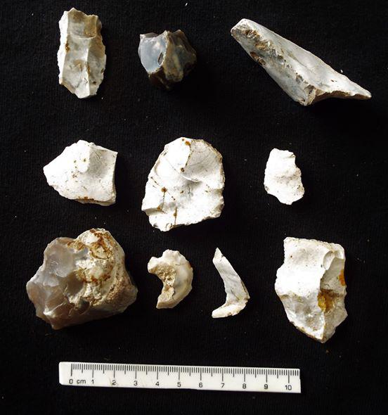
Today’s photos of the test pit compacted ash surface, and of the flint finds from the topsoil above the compacted surface, top to bottom left to right: blade, small worked out core, possible knife, 3 struck flakes, 4 retouched pieces/flakes.
My wife, Gilly, starts trowelling one side, after going through an inch of softish ash/clinker she says “Oh, feels like concrete”. I was a bit gutted she found it and not me! So, we scrape away and yes it does feel solid, impossible to trowel so had a good dig in and managed to break through, it was a two inch thick layer of compacted ash and clinker, really solid. Definitely not a floor as it wasn’t level and followed the downward contour of the slope, not a road surface as not thick enough to support a horse and cart. As it was 10 metres south of our shrub planting efforts it was clear that this compacted surface extended some distance, my guess is it was an assembly area or a very wide pathway between huts. We excavated this surface which was sitting directly on subsoil. There was one find directly underneath, a small piece of white china, probably from a plate or saucer, although I can’t imagine soldiers with saucers! We can assume that all the topsoil we have excavated is imported/created post 1919!
So, the mystery of the hard shrub planting was solved.
The excavation continues!
Today’s photos of the test pit compacted ash surface, and of the flint finds from the topsoil above the compacted surface, top to bottom left to right: blade, small worked out core, possible knife, 3 struck flakes, 4 retouched pieces/flakes.
Downside, Shoreham Test Pit Day 5
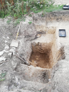
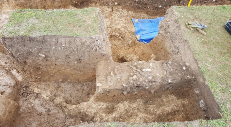
We are now trowelling through a silty fine subsoil with scattered flint nodules 1-3 inches, many broken and some by human hand. We excavated about 3 inches when flint nodules became more common together with a number of pieces of burnt flint, and still some worked flints appearing. After a further 3 inches flecks of chalk appeared and over the next few inches small lumps of chalk, before we reached lumpy chalk bedrock at about 30 inches from the surface, the last few inches yielded no finds.
Other than the one piece of white china there were no other finds of historic origin below the compacted ash surface, the surface was so compact that no worms were able to penetrate below.
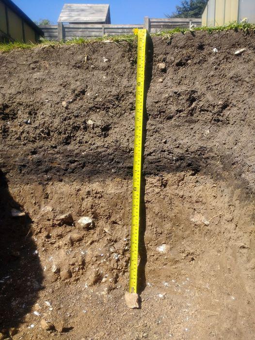
Photo of the profile today.
Last report tomorrow.
We are now trowelling through a silty fine subsoil with scattered flint nodules 1-3 inches, many broken and some by human hand. We excavated about 3 inches when flint nodules became more common together with a number of pieces of burnt flint, and still some worked flints appearing. After a further 3 inches flecks of chalk appeared and over the next few inches small lumps of chalk, before we reached lumpy chalk bedrock at about 30 inches from the surface, the last few inches yielded no finds.
Other than the one piece of white china there were no other finds of historic origin below the compacted ash surface, the surface was so compact that no worms were able to penetrate below.
Photo of the profile today.
Last report tomorrow.
Downside, Shoreham Test Pit Day 6
2 May 2020
Of course, the hole needed filling, we did it layer by layer and made such a good job with compaction that when we put the turves back, we had a dip! Had to import soil from elsewhere to top it up.
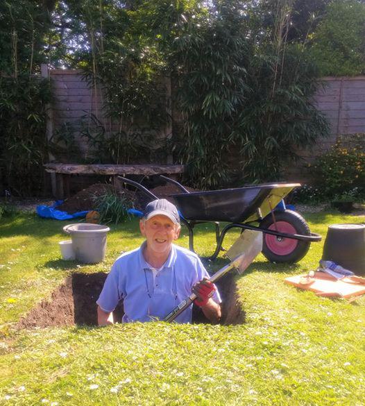
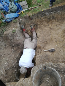
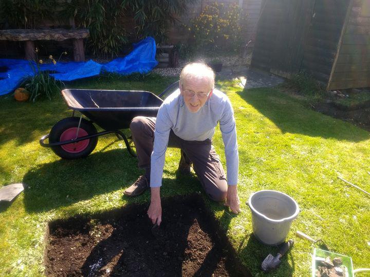
We sent this photo to the family; they were horrified that I was standing in such a deep hole! I was actually on my knees in a two-and-a-half-foot deep hole!!!! And no, I wasn’t actually using that pointy spade!
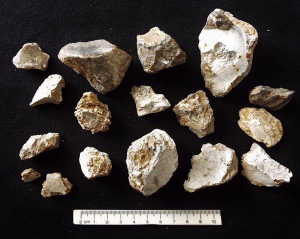
Today’s final two finds photos from below the compacted ash surface are of the burnt flint (top photo) and of the flint finds top to bottom left to right: thick roughly retouched scraper, retouched flake, possible concave scraper, 4 small retouched flints to be further researched, 2 small and 1 large core fragments, 2 possible knives, and 4 retouched flakes/pieces.
I find it astonishing that a randomly dug test pit could produce so many pieces of worked prehistoric flint, just shows what is underground on the lower slopes of the South Downs. And I have no intention of excavating my garden!!!!
Best wishes to all, hope to get digging at Sompting soon, even with a face mask!
2 May 2020
Of course, the hole needed filling, we did it layer by layer and made such a good job with compaction that when we put the turves back, we had a dip! Had to import soil from elsewhere to top it up.
We sent this photo to the family; they were horrified that I was standing in such a deep hole! I was actually on my knees in a two-and-a-half-foot deep hole!!!! And no, I wasn’t actually using that pointy spade!
Today’s final two finds photos from below the compacted ash surface are of the burnt flint (top photo) and of the flint finds top to bottom left to right: thick roughly retouched scraper, retouched flake, possible concave scraper, 4 small retouched flints to be further researched, 2 small and 1 large core fragments, 2 possible knives, and 4 retouched flakes/pieces.
I find it astonishing that a randomly dug test pit could produce so many pieces of worked prehistoric flint, just shows what is underground on the lower slopes of the South Downs. And I have no intention of excavating my garden!!!!
Best wishes to all, hope to get digging at Sompting soon, even with a face mask!